Infiniti I35 (A33). Manual - part 460


  Index      Infiniti     Infiniti I35 (A33) - service repair manual 2004 year


Search            


Content   ..  458  459  460  461   ..


Infiniti I35 (A33). Manual - part 460


Possible cause

Drive condition

Service procedure

Opera-
tion

Driving immediately after starting engine.

The gyro (angular velocity sensor)
needs about 15 seconds after the
engine is started to precisely sense
the angular velocity.
Directional sensing errors will occur
if the vehicle is moved immediately
after starting the engine. The posi-
tion marker may indicate inaccurate
position.

Wait a few moments
between starting the engine
and actually driving the
vehicle.

Continuous driving for long distances (non-stop)

When the vehicle is driven continu-
ously without stopping over a long
distance, errors in directional sens-
ing may occur. The position marker
may indicate inaccurate position.

Stop the vehicle. Perform
“Speed Calibration” (EL-422).

Rough or violent driving

Wheel spinning (peeling out) or simi-
lar rough driving techniques can
adversely affect sensing accuracy.
The position marker may indicate
inaccurate position.

If the position marker does
not move to the correct posi-
tion even after the vehicle
has been driven approxi-
mately 10 km (6 miles), per-
form “Adjust Current Loca-
tion” MODE (EL-429).

Posi-
tional
calibra-
tion
proce-
dures

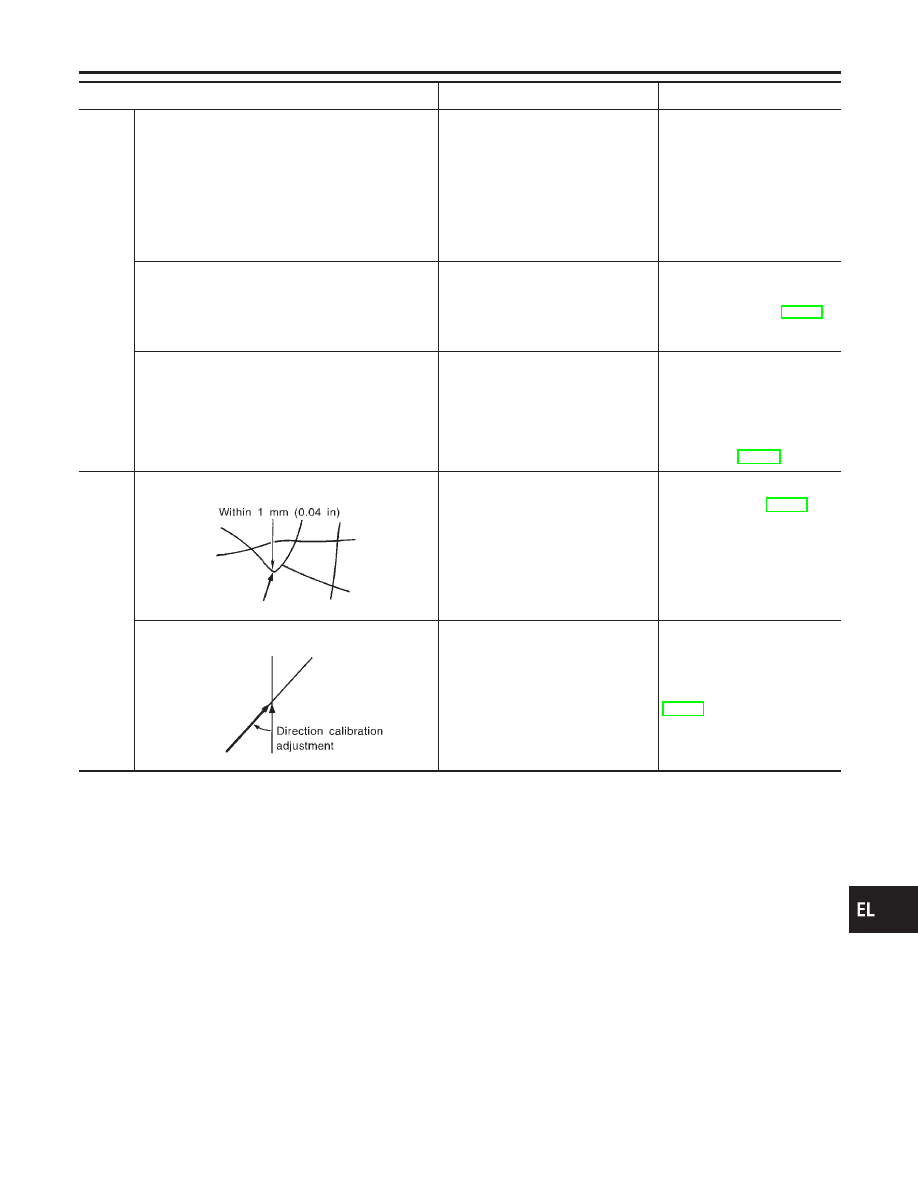
Positional calibration precision

SEL701V

If current vehicle location is roughly
set, the system may be unable to
locate the road that the vehicle is
traveling on. (This is especially true
in an area where there are many
roads.)

Perform “Adjust Current
Location” MODE (EL-429)
within a precision standard of
1 mm (0.04 in) on the dis-
play.
NOTE:
During calibration, use the
most detailed map possible.

Position calibration direction

SEL702V

When calibrating the position, check
the vehicle direction. If the vehicle
direction is not correct, subsequent
precision of current location will be
affected.

Perform “Adjust Current
Location” MODE, refer to
EL-429.

GI

MA

EM

LC

EC

FE

AT

AX

SU

BR

ST

RS

BT

HA

SC

IDX

NAVIGATION SYSTEM

This Condition Is Not Abnormal (Cont’d)

EL-441

Possible cause:

—: Vehicle running

---: Indication

Drive condition

Service procedure

Road
shapes

Y-intersection

SEL703V

In Y-intersections with a very gradual
change in course, a directional sens-
ing may be inaccurate. This may
result in the position marker giving
the wrong road indication.

If the position marker does
not move to the correct posi-
tion even after the vehicle
has been driven approxi-
mately 10 km (6 miles), per-
form “Store place”. If
required, also perform
“Adjust Current Location”
MODE (EL-429).

Spiral road

SEL704V

On loop bridges and similar struc-
tures which result in a large and
continuous turn, turning angle may
be sensed inaccurately. As a result,
the position marker may separate
from the route on the map.

Straight road

SEL705V

In long distance driving on a straight
road or road with very gradual
curves, map marking inaccuracies
may occur. In such cases, the posi-
tion marker may stray from the route
being traveled during subsequent
turns due to inaccurate distance cal-
culation.

Winding road

SEL706V

Directional sensing precision errors
may occur when traveling on wind-
ing roads. During map matching, the
position marker may stray to an
adjacent road having a similar
shape. Subsequent position marker
error may occur.

Grid-like road shape

SEL707V

Directional sensing and distance
sensing, precision errors may occur
because of many roads having a
similar shape in the immediate area.
During map matching, the position
marker may stray to an adjacent
road having a similar shape. Subse-
quent position marker error may
occur.

Parallel roads

SEL708V

When driving on a parallel road,
map matching errors may occur.
Subsequent position marker error
may also occur.

NAVIGATION SYSTEM

This Condition Is Not Abnormal (Cont’d)

EL-442

Possible cause:

—: Vehicle running

---: Indication

Drive condition

Service procedure

Loca-
tion

Parking lot or similar area

SEL709V

When the vehicle is driven in a park-
ing lot or similar area, such as in an
area not normally marked as a road
on map, during map matching, the
system may select nearby roads.
This error may continue after the
vehicle exits the parking area and
begins to run on ordinary roads.
Vehicle operation in a parking area
may involve frequent turns and up
and/or down operation. Directional
sensing errors may occur leading to
subsequent route and position mis-
takes.

If the position marker does
not move to the correct posi-
tion even after the vehicle
has been driven approxi-
mately 10 km (6 miles), per-
form “Store place”. If
required, also perform
“Adjust Current Location”
MODE (EL-429).

Turntable

SEL710V

When the ignition switch is OFF (the
usual situation when the vehicle is
on a turntable), the navigation sys-
tem receives no data from the gyro
(angular velocity sensor). When the
turntable rotates, no directional
change is sensed. During subse-
quent vehicle operation, directional
and route errors may occur.

Position marker displays a completely different location
In circumstances such as those described below, GPS signal reception conditions may result in an erroneous
position of the position marker. Perform “Adjust Current Location” MODE (EL-429).
NOTE:

I

When GPS satellite signal reception conditions are poor, the position of position marker may be errone-
ous. If correction is not made immediately, the position marker error will be compounded and a completely
different location will be indicated. In an area where GPS satellite signal reception conditions are good,
the system can be returned to normal operation.

I

The vehicle is driven aboard a car ferry or is towed for some distance with the ignition switch OFF. Vehicle
movement is not sensed. Current location calculations do not occur and current location data does not
appear on the display screen. Use GPS to accurately determine actual vehicle position. The system can
be returned to normal operation when the GPS satellite signal reception conditions are good.

Position marker jumps
In circumstances such as those described below, the position marker may jump as a result of automatic cur-
rent location corrections made by the system.
During map matching

I

During map matching, the position marker may jump from one spot to another. In this case, it may be cor-
rected to a wrong road or to an area where no road exist.

GPS location correcting

I

Vehicle current location is sensed using the GPS data. Positional calibration is performed. The position
marker continues to be in the wrong position. It may jump about from one area of the screen to another.
In this case, it may be corrected to a wrong road or to an area where no road exist.

Position marker indicates that the vehicle is in the middle of an ocean or large river
The navigation system does not distinguish between land and water surfaces. In some cases, a position
marker error may cause the display to show the vehicle above a water surface.
Position of position marker varies when the vehicle is repeatedly operated on the same road
Driving lane and steering wheel movement results in a variety of different positions of the position mark when
traveling on the same road based on sensing results by the GPS antenna and gyro (angular velocity sensor).
Slow locational correction using map matching

I

The map matching function requires verification of local data. To make the map matching function, some
distance needs to be driven.

I

The map matching function may not provide accurate performance in an area where there are numerous
parallel roads. Until the system judges the road characteristics, an incorrect position may be shown.

GI

MA

EM

LC

EC

FE

AT

AX

SU

BR

ST

RS

BT

HA

SC

IDX

NAVIGATION SYSTEM

This Condition Is Not Abnormal (Cont’d)

EL-443

GPS signal reception conditions are good. However, the position mark does not return to its proper
position.

I

The system senses the vehicle location with an error of approximately 100 m (328 ft). Due to the limita-
tion of precision, the position marker may be inaccurate even if the GPS signal reception condition is good.

I

The navigation system uses GPS data to determine vehicle location. GPS data is compared with other
locational sensing data during the map matching process. The system decides which data is more pre-
cise and uses that data.

I

When the vehicle is stationary, GPS data cannot be used to make system corrections.

Area designations on the map display and the BIRDVIEW

T

display differ.

To prevent the display from becoming congested, alphanumeric information is abridged.
[No problem]
Correct position of your vehicle is not displayed.
Vehicle position changed after ignition key was turned to the OFF position (Vehicle is transported on car ferry,
car train, or by some other means).
[Operate vehicle for short time under GPS receiving conditions.]
The display does not change to night-time mode even though the light switch has been turned ON.
Lights have been turned on. In “DISPLAY CHANGE” mode, night-time mode on display has been switched to
day-time mode and still is.
[Turn lights on again. Set the display to night-time mode. Refer to EL-428.]
Map does not scroll even though the position of your vehicle is changed.
Present area does not appear on the display.
[Press the “MAP” switch.]
Vehicle position marker does not appear.
Present area does not appear on the display.
[Press the “MAP” switch.]
The map surface precision display (GPS satellite marker) still remains gray.
Vehicle is parked inside a building or in the shadow of a large building. This intercepts the GPS signal.
[Move the vehicle to a more open position.]
GPS signal is not received because objects are placed on the rear parcel shelf.
[Remove objects from the rear parcel shelf.]
GPS satellite position is bad.
[Wait until GPS satellite position improves.]
Vehicle position precision is bad.
The map surface precision display (GPS satellite marker) still remains gray.
[Refer to “The map surface precision display (GPS satellite marker) still remains gray” item (Symptoms)]
Vehicle speed and elapsed distance is calculated from the vehicle speed pulse. This pulse is dependent upon
tire size. If tire chains are used on the vehicle, accuracy will be affected (pulse rate will be too fast or too slow).
The same is true if the system installed to your vehicle is removed and installed on another vehicle.
[Drive the vehicle at a speed higher than 30 km/h (19 MPH) for approximately 30 minutes. Automatic read-
justment should occur. If it does not (remains too fast or too slow), distance calibration is required. Or, drive
the vehicle for a short distance. Perform “SPEED CALIBRATION” (EL-422). After removing the tire chains,
sensing accuracy may recover by itself.]
Bad map data or system defect (same error consistently occurs in the same area)

ROUTE SEARCH/ROUTE GUIDE

NHEL0304S03

I

If the present location or the destination location is displayed in the avoid area, it is not possible to search
routes.

I

If the avoid area is set to wide range area, it may not be possible to find appropriate routes or search for
alternate routes.

I

The automatic re-route calculates a return to the original route. Because of this, it may not be possible to
search appropriate new routes. If you deviate from the original route and wish to select an appropriate new
route, touch “Route Calculation”.

I

The automatic re-route function may sometimes require considerable time.

I

Displayed route number and directional information at a highway junction may differ from the information
posted on the actual road signs.

I

Displayed street name information at a highway exit may differ from the information posted on the actual
road signs.

I

Street name information displayed on the enlarged intersection map may differ from the information posted
on the actual road signs.

NAVIGATION SYSTEM

This Condition Is Not Abnormal (Cont’d)

EL-444


Content   ..  458  459  460  461   ..