Honda Odyssey 2004. Manual - part 508


  Index      Honda     Honda Odyssey 2004 - service repair manual 2004 year


Search            


Content   ..  506  507  508  509   ..


Honda Odyssey 2004. Manual - part 508


―――

*07

*08

*09

*10

Global Positioning System (GPS)

Position detection Image with GPS satellite

Precision of GPS

GPS ICON

No.of

SATELLITES

CONDITION

DESCRIPTION

GPS Antenna

GPS Receiver

22-360

Navigation System

System Description (cont’d)

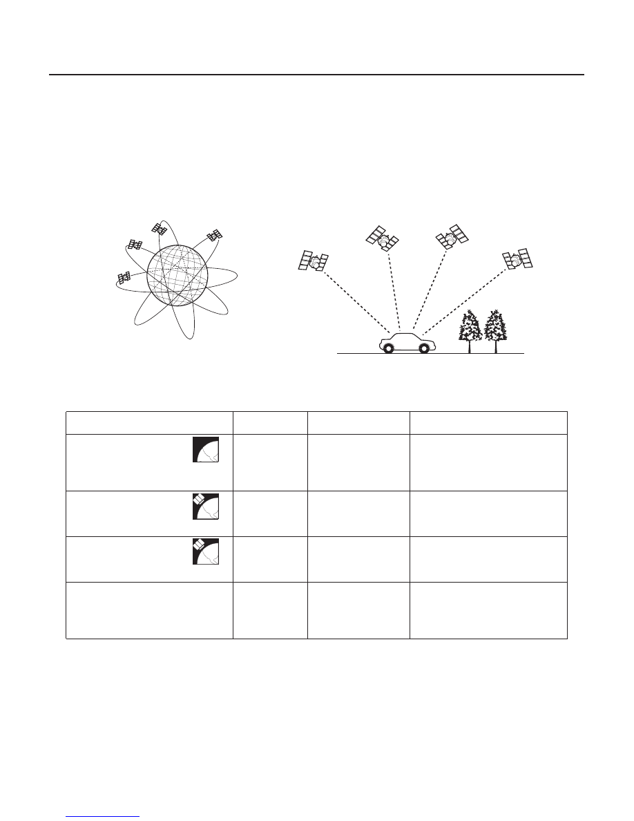
The global positioning system (GPS) enables the navigation system to determine the current position of the vehicle by
utilizing the electronic waves transmitted from the satellites in orbit around the earth. The satellites transmit the
satellite identification signal, orbit information, transmission time signal, and other information. When the GPS
receiver receives the electronic waves from three or more satellites simultaneously, it calculates the current position
of the vehicle based on the distance to each satellite and the satellite positions on their respective orbits.

The precision of the GPS varies according to the number of satellites from which electronic waves are received and
the control condition. The precision is indicated by the GPS mark shown on the upper left of the display.

No
satellite
mark

Two or less

Impossible to detect
vehicle position

The GPS function is normal.
The satellite electronic waves
received by the GPS receiver are
too few to determine the vehicle
position.

Yellow
satellite
mark

Three

Vehicle position
detectable in two
dimensions

The longitude and latitude of the
vehicle position can be
determined. (Less precise than
detection in three dimensions)

Green
satellite
mark

Four or more

Vehicle position
detectable in three
dimensions

The longitude, latitude and the
altitude of the vehicle position can
be determined. (More precise
than detection in two dimensions)

Not indicate

Faulty

The GPS can’t be utilized due to a
faulty GPS receiver, open in the
antenna wire, disconnected
antenna, or other outside
interference.

The GPS antenna amplifies and transmits the electronic waves received from the satellites, to the GPS receiver.

The GPS receiver is built into the navigation unit. It calculates the vehicle position by receiving the signal from the GPS
antenna. The vehicle position and signal reception condition is transmitted from the GPS receiver to the navigation
control unit to adjust the vehicle position.

NOTE: Four satellites on each of six orbits.

03/07/29 10:28:38 61S0X050_220_0362

Navigation Unit

Calculation of Vehicle Position

Map Matching Tuning

GPS Tuning

Distance Tuning

Route Guidance

Audio Guidance

DVD-ROM

22-361

The navigation unit calculates the vehicle position and guides you to the destination. The unit performs map matching
correction, GPS correction, and distance tuning. It also controls the menu functions and the DVD-ROM drive. With
control of all these items, the navigation unit makes the navigation picture signal, then it transmits the signal to the
display unit and audio driving instructions to the audio unit.

The navigation unit calculates the vehicle position (the driving direction and the current position) by receiving the
directional change signals from the yaw rate sensor and the travel distance signals from the vehicle speed pulse (VSP)
sensor.

The map matching tuning is accomplished by indicating the vehicle position on the roads on the map. The map data
transmitted from the DVD-ROM is checked against the vehicle position data, and the vehicle position is indicated on
the nearest road. Map matching tuning does not occur when the vehicle travels on a road not shown on the map, or
when the vehicle position is far away from a road on the map.

The GPS tuning is accomplished by indicating the vehicle position as the GPS’s vehicle position. The navigation unit
compares its calculated vehicle position data with the GPS vehicle position data. If there is a large difference between
the two, the indicated vehicle position is adjusted to the GPS vehicle position.

The distance tuning reduces the difference between the travel distance signal from the VSP and the distance data on
the map. The navigation unit compares its calculated vehicle position data with the GPS vehicle position data. The
navigation unit then decreases the tuning value when the vehicle position is always ahead of the GPS vehicle position,
and it increases the tuning value when the vehicle position is always behind the GPS vehicle position.

The navigation unit can calculate different routes to a selected destination. You have four options:

• Direct Route

Calculate a route that is the most direct and will take the least time.

• Easy Route

Calcute a route that minimizes the number of turns needed.

• Minimize Freeways

Calculate a route that avoids freeway travel. If that is not possible, keep the amount of

freeway travel to a minimum.

• Mimimize Toll Roads

Calculate a route that avoids, or minimizes travel on toll roads.

The navigation unit transmits audio driving instructions before entering an intersection or passing a junction.
The audio instructions come through the audio unit and the front speakers.

The map data (including all scale rates) is stored in the DVD-ROM. The map data includes:

• Road distances, road widths, speed limits, traffic regulations, passing time at junction, distances to junctions, and

the driving instructions for audio guidance.

• Latitude and longitude GPS.

(cont’d)

03/07/29 10:28:38 61S0X050_220_0363

Glossory

22-362

Navigation System

System Description (cont’d)

The following is a glossary of terms used pertaining to the Navigation system.

POI

Point of Interest, these are listed under the ‘‘places’’ option on the Main Menu.

PIN

Personal identification number, a random number created by the user(s) to
protect personal information.

GPS

Global positioning system. A network of 24 communication satellites orbiting
the earth.

NAVI

Abbreviation for navigation system.

LCD

Liquid crystal display.

PCM

Powertrain control module.

DCA

Digital coverage area, an area that is covered in the database digital mapping.
For example, the 48 continuous United States are within the DCA. Hawaii and
Alaska are outside of the DCA.

Detailed Coverage Areas

Major city and metropolitan areas have detailed coverage of streets and
addresses.

Outlying Areas

Outlying areas have coverage of major roads and highways only.

VSP

Vehicle speed pulse. A travel distance signal supplied by the PCM.

DATABASE

The data (mapping and address information) stored on the DVD-ROM disc and
in the navigation system’s control unit.

DVD-ROM

Digital video disk read-only memory.

DIGITIZED ROAD

A road that appears on the navigation digitized map screen.

NON-DIGITIZED ROAD

A road that DOES NOT appears on the navigation digitized map screen.

Map Matched (ing)

The navigation system has matched the car to a digitized road segment which
is represented when the name of the current road being driven on is indicated
in the bottom of the screen in the blue shaded area.

03/07/29 10:28:39 61S0X050_220_0364

06

Audio Unit

Display Unit

Infrared Rays

22-363

: Infrared for touch switch

The audio unit receives the audio driving instructions from the navigation unit and transmits the instructions through
the front speakers even when the audio system is in use.

The display unit uses liquid crystal display (LCD). The LCD is a 6-inch-wide, thin film transistor (TFT), stripe type with
280,800 picture elements, The color film and fluorescent light are laid out on the back of the liquid crystal film. The
touch sensor on the front of the LCD is an infrared type with 10 vertical and 7 horizontal infrared rays to produce 70
sensing points. The display unit transmits the signal from each operation key and the touch switches to the navigation
unit.

03/07/29 10:28:39 61S0X050_220_0365


Content   ..  506  507  508  509   ..